Click on your picture in the top right corner, go to Preferences and select your notification preferences.
Please keep in mind:
1. To only comment on the topic where the discussion is about. Do you have a new question or topic? Please start a new discussion.
2. Be kind to other users!
Water storage terrain surface

Dear forum users,
I am currently working with the water balance in the water module/rainfall overlay. I am interested in the amount of water stored on the land surface and water surface. I have 3 questions regarding this.
If I understand the water balance correctly, The left side of the balance shows the amount of water present on the water surface at the start of the simulation. On the right side of the balance, both the amount of water present on the water surface and the land surface at the end of the simulation are shown.

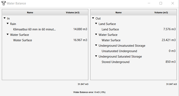
I am wondering which queries are used to come to these values.
I tried to calculate the values myself, but could not come to these values. I used the following approach and querys:
Step 1: calculate water storage in entire area:
a. Initial situation
Water Storage entire area at t=0: SELECTGRIDVOLUMEWHERE GRIDIS_ idoverlay Oppervlak laatste waarde_AND_TIMEFRAME_IS_0_AND_MAP_IS_ CURRENT
b. Final situation
Water Storage entire area at t=x: SELECTGRIDVOLUMEWHERE _GRID_IS_ idoverlay Oppervlak laatste waarde_AND_TIMEFRAME_IS_x_AND_MAP_IS_ CURRENT
c. Total Water storage = water Storage entire area at t=x – Water Storage entire area t=0
Step 2: calculate water storage on the water surface (oppervlaktewater)
a. Initial situation
Storage water surface t=0: SELECTGRIDVOLUMEWHERE GRIDIS idoverlay Oppervlak laatste waarde AND_TERRAIN_WITH_ATTRIBUTE_IS_WATER_ AND_TIMEFRAME_IS_0_AND_MAP_IS_CURRENT
b. Final situation
Storage water surface t=x: SELECT_GRIDVOLUME_WHERE _GRID_IS_ idoverlay Oppervlak laatste waarde _AND_TERRAIN_WITH_ATTRIBUTE_IS_WATER_ AND_TIMEFRAME_IS_x_AND_MAP_IS_CURRENT
c. Water storage water surface = Storage water surface t=x - Storage water surface t=0
Step 3: calculate water storage on the land surface (maaiveld)
a. Water Storage land surface = Total Water storage - Water storage water surface
Important to note here is that I defined timestep t=0 as the time stap at zero seconds, so before an precipitation event actually started. T=x in my case is at timestep 21, at the very end of the simulation.
In the table below I show the results of two of the calculations I did. The first/left is done for a real 3D environment on the entire project area, the second/right is done on a specific part of a manually created project (see attached pictures).
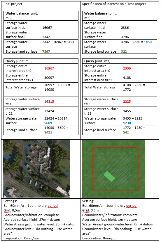
As can be seen, the storages on the water surface and land surface do not match each other. So for this reason I am interested in what queries I should use to come to the values as presented in the water balance. (My first question)
Then there is a second thing that draws my attention. I would expect that at t=0, that the water stored at the water surface is equal to the total water storage in the area. More concrete, I would expect the “Storage entire interest area t=0” (step 1a) to be equal to “Storage water surface t=0” (step 2a). (Red values, table above). I would expect this because I set the first time step at 0 seconds, thus the only water present on the surface is the water in the water areas (terrain type water, and attribute “water”). No rain water would be present on the terrain surface. In step 1a, I request al water present on the terrain surface in the entire area, step 2a request the water present on the surface of water areas. To be sure there is no influence of precipitation on these values, I also looked at this situation by putting the precipitation amount at 0mm/hour. This made no difference on the outcomes.
My question in this is why these values are not the same? (Question 2)
Besides the precipitation, I thought that maybe this difference at t0 could be caused due to water sored at the edges of the waterbody. The edge of the water body has a slope (talud). I thought that maybe water stored at the slope was considered to not be part of the water surface. To check this, I experimented with changing the ANGLE OF REPOSE attribute of the underground terrain type. However, by changing this value to several different values, no changes in the initial storages were observed.
So my third question is, what is the purpose of the angle of repose? (https://support.tygron.com/wiki/Angleofrepose(TerrainAttribute))
I hope someone can help me out with my questions!
Kind regards and have a nice (working) week,
Thies


Comments
Hello Thies,
As a preface I do recommend splitting of different questions into different threads/posts, to make it a bit more manageable to gauge where one question ends and another begins, and also to make it easier for others for learn from the same questions and information.
Water balance, on land and on water
For the first question, I would like to start of with the detail that the water balance does not use queries, neither for the input or for the output. It is built up directly from the data as it calculated by the Water Overlay.
I can quickly see the discrepancy in the values you expect is in one of your queries. The water balance splits out the amount of water between "on land" and "on water". In your query for retrieving water on water terrains, you correctly add WHERE-TERRAIN-WITH-ATTRIBUTE-IS-WATER. But for the water on land, you include no such clause. Thus you retrieve all the water, be it on land or on water. If you look closely at the results, the value returned from that query actually matches quite closely with the sum of the values in the water balance.
Water balance, start total is not only on water
There are two likely factors at play here. Like Areas, as described in an earlier thread, Terrains are also present in Tygron as vector data, which is rasterized later on. By using the "TERRAIN-WITH-ATTRIBUTE" clause, you are again introducing a cookie-cutter effect into the data. The difference is small, and will be smaller relative to the actual totals as the project gets bigger.
Secondly, it's also very likely that there is a shoreline effect. Read more about shoreline effects here: https://support.tygron.com/wiki/Shoreline_(Water_Overlay).
What you described, but then attributed to potentially the angle of repose, is a correct phenomenon, and one the Water Overlay takes into account by (by default) extending the water onto the shores (otherwise there would be a sudden shock of water flow at the start of the simulation).
Angle of repose
The angle of repose is used when modifying the terrain to change from land to water or the other way around. Read more about water generation here: https://support.tygron.com/wiki/Elevation_model#Water.
It is only used when such a modification is made. After the water is placed, be it through the initial project generation or by drawing in water manually, the angle of repose is not relevant to the elevation model or the geographical configuration of the terrain types. Similar to how, if you import a geojson, the data in the geojson is used to create or modify features in the project, but afterwards the file itself is not actively related to the data, and modifying the file does not modify the created data.