Receive email notifications by changing your settings.
Click on your picture in the top right corner, go to Preferences and select your notification preferences.
Click on your picture in the top right corner, go to Preferences and select your notification preferences.
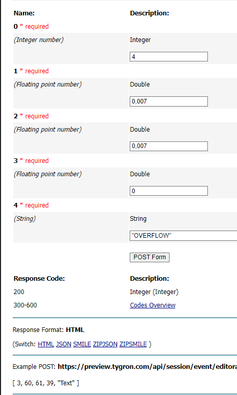
API syntax api/session/event/editorarea/generate_sewer_areas/

in Data
What is the correct syntax for the final parameter that allows you to generate the sewer overflows via the API. It's about the lowest checkbox in the wizard
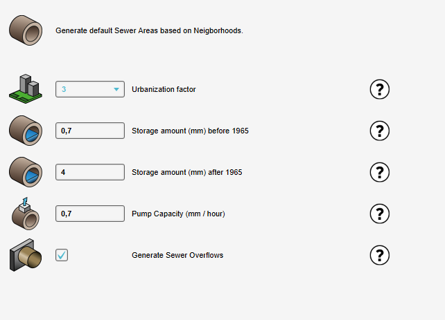
It's stated as a required field "string". But the option itself is more a boolean (yes or no to generate). The API webpage doesn't give any hint at all, no forum post yet, no wiki and no way to find out what the wizard actually sends along itself. I tried a lot of options already but can't figure it out. What syntax should parameter 4 be to enable and disable the checkbox
Tagged:
Comments
Hi Len,
I had to check internally, but I've got some clarity.
The last parameter is the Attribute by which Water Areas are recognized.
When, in the wizard, the checkbox to generate overflows is checked, the software automatically computes valid locations for sewer overflows. Overflows are generated in locations which meet 3 requirements: There's a Sewer area, there's water, and there's a Water Area. The string Attribute is the keyed attribute for the Water Area. I.e., when generating without having changed any of the Overlay Keys, the correct input would be "WATER_LEVEL" (without the quotation marks). This signals within the event call which Area's to consider Water Areas, and thus where sewer overflows can be generated.
Regards!
Sprawling spreadsheets so intricate Alexander the Great cuts them in half.
Hi Rudolf,
Thank you. I now understand. I did create a tool myself that does the exact same thing but then outside of Tygron. Get centerpoint of the water area, get center point of each water terrain type. See which one is closest and match those. If there's no water body in the waterlevel area then it'll get no overflow. So I excluded the check for the water area.
Not sure though about the third criteria, there having to be a water area as well. I understand the sewer area and water terrain type. But plenty of regions in NL might not have water level areas where technically the third criteria would never be met. But I got my work around doing pretty much the same thing.
Good to now know what the string should have been (this would be a good call to add some documentation for each input other then the data type).