The Tygron Community Forum will be discontinued on March 6th 2026, matching the release of the 2026 version of the Tygron Platform.
Click on your picture in the top right corner, go to Preferences and select your notification preferences.
Please keep in mind:
1. To only comment on the topic where the discussion is about. Do you have a new question or topic? Please start a new discussion.
2. Be kind to other users!
Data collection for area in Australia

Dear Tygron,
We are currently investigating the use of Tygron for climate risk analyses of two supermarkets in Australia:
Woolworths Coorparoo Brisbane (https://www.google.com/maps/place/Woolworths+Coorparoo/@-27.4937419,153.0570068,15z/data=!4m2!3m1!1s0x0:0x13f60102c55c3afc?sa=X&ved=2ahUKEwjSyu7ekvzzAhXuSvEDHQquAloQ_BJ6BAhkEAU)
OSM: https://www.openstreetmap.org/query?lat=-27.49370&lon=153.05706
OSM: https://www.openstreetmap.org/#map=17/-33.87035/151.03346
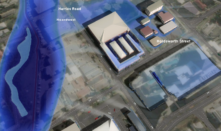
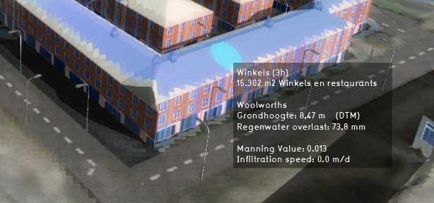
We created a Tygron model for the areas around the supermarkets, but found that the data collection for these areas is far from complete. Many buildings (mainly housing blocks) are missing, and the height of the buildings that are present (among others: the supermarkets) doesn't seem to be correct. The result is considerable water depth on what should be the roof of the supermarket because the height is the same as the surroundings. See figures below.
We were wondering if this is often the case with urban areas in Australia. We saw that the OSM data is not complete and the ESRI DEM might not be ideal either in Australia?. But if there is a building registered in OSM (like the supermarkets), shouldn't it be assigned a default building height in Tygron, instead of no building height?
could you please let us know if you have experienced this previously in Australia, and if there is a way to collect the data in a different (automatic) manner so that the modelled heights of buildings are closer to the real height.
Keen to hear from you.
Kind regards,
Glenn

Comments
Dear @Glenn Morvan ,
For areas outside the Netherlands we only have limited experience with enriching the default datasets. Usually we work together with local parties that have more acurate datasets available, sometimes propriatary, sometimes public. Maybe local universities or other educational or public instututes have datasets available for that area in Australia?
I did find some data frome the government for brisbane: https://qld.digitaltwin.terria.io/
All from this site: https://nationalmap.gov.au/
I hope this helps, maybe some other users can chime in?
Regards, Vincent
Digital Twin 3D: Brisbane
Dear @Glenn Morvan ,
Would it be possible for you to share your project with support? We would like to have a look at the water-on-roof issue we see in your screen shots.
Best regards,
Vincent
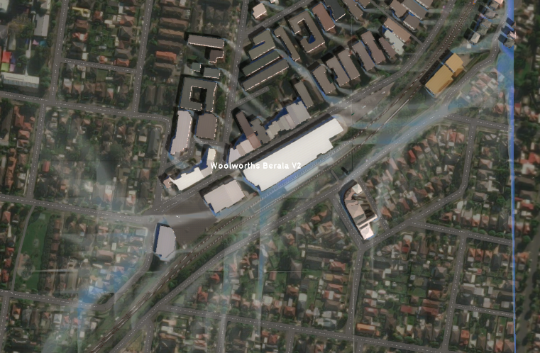
Hi @vincent.rd ,
I just shared my projects.
Names:
-Woolworths Berala V2
-Coorparoo Brisb V2
-Coorparoo Brisb V22
Thanks!
Kind regards,
Glenn
Dear @Glenn Morvan ,
Thank you for sharing your projects, I will pass them on to R&D.
Best regards,
Vincent
Dear support,
thanks for the input on the Australian Case. We have managed to complete that case.
Currently, we received a similar question for an area in China in which we encounter similar challenges. The DEM of the area seems to be to quite inaccurate and many buildings are missing.
Do you have any tips on open source data collection for the Shanghai area or can you help me in some other way? We will enquire our contacts in China on any data they have, but it would be nice if we can also improve this (relatively small) model ourselves to showcase.
I have made the project available for support. It's called: "Shanghai Parkview".
Keen to hear from you!
Kind regards,
Glenn Morvan
Hello @Glenn Morvan ,
I ran into this: https://www.unrealengine.com/en-US/spotlights/51world-creates-digital-twin-of-the-entire-city-of-shanghai
Maybe this can be of help?
We will also discuss this internally, and will come back to you.
Best regards,
Vincent
Thank you Glenn for your input. We took a look at your projects, but the result is mainly a summary of what was already said earlier; There are several relevant aspects to working with data worldwide:
Don't hesitate to let us know if you have remaining questions?
Hedi
Tygron Support Team