The Tygron Community Forum will be discontinued on March 6th 2026, matching the release of the 2026 version of the Tygron Platform.
Receive email notifications by changing your settings.
Click on your picture in the top right corner, go to Preferences and select your notification preferences.
Click on your picture in the top right corner, go to Preferences and select your notification preferences.
Thank you for contributing to our forum!
Please keep in mind:
1. To only comment on the topic where the discussion is about. Do you have a new question or topic? Please start a new discussion.
2. Be kind to other users!
Please keep in mind:
1. To only comment on the topic where the discussion is about. Do you have a new question or topic? Please start a new discussion.
2. Be kind to other users!
Set groundwater key value to relative (and assign correct geotiff) with the API

Hi,
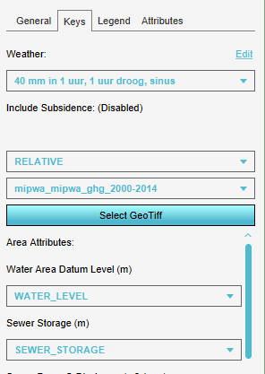
I'm tryging to create an overlay with a resulttype Ground Last Storage. And I'd like to use my own data for the initial groundwater table (ia a tiff).
If I use the Rainfall wizard in the Tygron interface and I upload my tiff-file, I can see that in the key-tab of my parent overlay there is a box set tot RELATIVE and it is set to the correct uploaded file (see image below). But how do I do this with the API? Do I use set key for this overlay?
Tagged:
Comments
Hey Ward,
when using the API to set a geotiff, you will use the following event:
https://engine.tygron.com/api/session/event/editoroverlay/set_ground_water_tiff/
The last parameter is a boolean value indicating whether the geotiff should be interpreted as a datum ground water level (DATUM, true), or the ground water distance relative to the elevation model (RELATIVE, false). When switching between the two, remember to set the other version to unused by setting it to geotiff id -1.
Be sure to check the data of your overlay in the aPI while switching between the two options in the user interface, and then also how the data looks right after firing your events via the API, to compare and see for yourself.