The Tygron Community Forum will be discontinued on March 6th 2026, matching the release of the 2026 version of the Tygron Platform.
Receive email notifications by changing your settings.
Click on your picture in the top right corner, go to Preferences and select your notification preferences.
Click on your picture in the top right corner, go to Preferences and select your notification preferences.
Thank you for contributing to our forum!
Please keep in mind:
1. To only comment on the topic where the discussion is about. Do you have a new question or topic? Please start a new discussion.
2. Be kind to other users!
Please keep in mind:
1. To only comment on the topic where the discussion is about. Do you have a new question or topic? Please start a new discussion.
2. Be kind to other users!
Using external DTM/Elevation data

in Data
Hi Everyone,
I am trying to import and use an external DTM for a project outside of the Netherlands.
The basis models uses ArcGIS elevation with an original resolution of 30*30m, but I (luckily) found an elevation model (DTM and DSM) with 0.5m resolution,
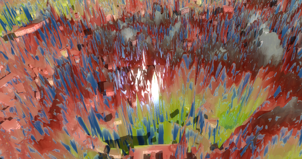
Now, when i try to import these models, I get the result below. The elevation map gets really 'spikey' and does not work correctly anymore in the overlays.
Does anyone have any tips on how to fix this? Maybe some pre-processing
in QGIS?
Comments
@Astrid
Hi @Andy.arcadis and @Astrid ,
Can you share the files with me (per email to support@tygron.com or as an attachment on the forum?
And how did you import the files? Can you add the steps?
Then I can have a look at it and help you further!
Tygron support team
Hello @Andy.arcadis and @Astrid ,
Thank you for sending the dataset.
We looked at it and we found out 2 things about it.
When you import the data set it gives a map with a deviation. It gives a height of 100 cm while in reality it is a height of 10 cm.
At the same time we discovered the data set is not a elevation model but a picture of a height map ( for example, you can see shadows in the image). We compared your data set with a actual elevantion model (exported form the Tygron Platform default elevantion map) and this confirms our suspicion that it is indeed not a height map but a picture of a height map.
I hope this answers your question.
Kind regards,
Hansje
Tygron support team