The Tygron Community Forum will be discontinued on March 6th 2026, matching the release of the 2026 version of the Tygron Platform.
Click on your picture in the top right corner, go to Preferences and select your notification preferences.
Please keep in mind:
1. To only comment on the topic where the discussion is about. Do you have a new question or topic? Please start a new discussion.
2. Be kind to other users!
How to create a Terrain Overlay
In the Tygron Platform terrain (surface) types have effect on indicators and overlays, such as the green indicator and the rainfall overlay. Read more about what terrain is here.
For analysis and debugging puposes, it would be useful to have a terrain overlay.
You can create this overlay yourself by following the steps below:
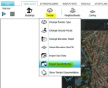
- Export the terrain data by hovering with your mouse in the tab Geo Data over the button Terrain. Click on Export GeoJSON file.
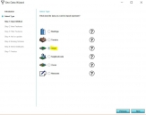
- Then import this file with the Geo Data Wizard (click in the tab Geo Data on Geo Import to start the wizard). If you are not familiair with the wizard, then please read the documentation first on how to use it.
- Choose to import as areas and continue with the wizard
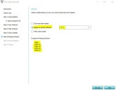
- Don't forget in step 5 to give the areas the name of the terrain type by using the TYPE attribute for the name.
- After you have finished the wizard, click on the Areas button in the Geo Data tab. Now you will see several areas in the panel on the left.
- Since we don't want to click on these areas one by one, but want to see them in one map/overlay, follow the steps here to create the overlay: http://support.tygron.com/wiki/Geo_Data_tutorial#Create_an_overlay
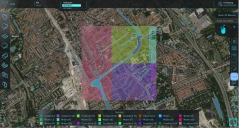
- Now we are finished and have a (static) map of the terrain!
There are some improvements for this map, for example merging the areas that are of the same terrain type.
After exporting the data, then adjusting it in a GIS and importing the data, above can be achieved.
Please let me know if this was helpful and/or if you would like me to add the steps how to improve the map using a GIS!


Tygron support team

Comments
Hi Godelief,
Thanks for your post. It's really helpful.
I've been looking for a way to visualize the surface types in an overlay in the Engine for quite some time. Last time I analyzed the surface-types in GIS after exporting the Geo-data. Never thought of importing the data as Areas to visualize it in an overlay though.
Would it be possible to create a 'default' overlay similar to the underground overlay in the near future?
Thijs