The Tygron Community Forum will be discontinued on March 6th 2026, matching the release of the 2026 version of the Tygron Platform.
Click on your picture in the top right corner, go to Preferences and select your notification preferences.
Please keep in mind:
1. To only comment on the topic where the discussion is about. Do you have a new question or topic? Please start a new discussion.
2. Be kind to other users!
Interaction between groundwater and water areas
Hi support,
I've recently noticed and oddity in the interaction between open water and ground water. I noticed them in a test model; a very simple, square Tygron model with very few additions to it.
The problem is the following:
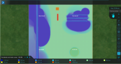
When I add water as a terrain feature to my model and then run the groundwater overlay, it seems to me that groundwater slowly seeps into the water body. Namely; around the water bodies, the groundwater table slowly drops. This is a bit strange, since Tygron shouldnt 'know' the height of my open water bodies (I added no water area), so I dont see how it can decide that the water there is lower than the groundwater table, thus enabling a flow.
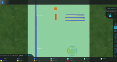
When I try to add Water Areas, to try and raise my waterbodies to the same height as my groundwater table, the overlay basically goes bananas. It adds a lot of water to the groundwater table (even though I have modelled without rain or inlets etc.). It also does so very irregularly, leaving an uneven pattern.
I have added a snip from both model outputs, see attachtments.
Again: the only difference in input is the addition of a water area.
I hope I have been able to clearly articulate the problem I'm encountering. Thank you for your help.
Thomas


Comments
Hello Thomas,
Most information can be found on these two pages, but this is not entirely corresponding with your question, therefore I give you some additional information as well.
http://support.tygron.com/wiki/Terrain
http://support.tygron.com/wiki/Terrain_height#Waterdepth
On our preview version we are currently working on various enhancements related to water flow models, and one of them is indeed how we create a baseline of water bodies. In the new version, we relate the water depth and the angle of repose for the water bodies to the terrain in that area. Specifically during the generation of a new project area, when a water terrain is found in a project area, the water body is carved into the base terrain. The angle of the sides of the water body is defined by the ANGLE_OF_REPOSE of the underground terrain type, and the maximum depth to which a water body is carved out is WATER_DEPTH_M as defined for the surface terrain type. If the angle of repose is shallow enough and the water body thin enough, the angled sides may meet up before the maximum water depth is reached. In this case the water body will be appropriately shallower.
I hope this combination of indepth information does answer your questions to your satisfaction.
Kind regards,
Hansje
Tygron support team
Hi Hansje,
Same story as the previous answer you gave; it does answer one of my questions, but I think you posted this answer on the wrong topic.
You probably meant to post this answer on the Topic 'Integration of bed levels in waterbodies of Tygron'.
Hi Thomas, This is the correct answer at the correct topic.
The distance is relative to the surface of the terrain. The impenetrable layer is a distance of GROUND_BOTTOM_DISTANCE_M below the surface. For every grid cell, the height of the impenetrable layer relative to datum can differ, following the profile of the height of the surface relative to datum.
Currently, the height of the impenetrable layer (relative to the surface) can only be configured as an attribute for the entire project area, and cannot be varied geographically.
Also, on these pages you can find some additional information:
http://support.tygron.com/wiki/Water_Overlay#GROUND_BOTTOM_DISTANCE_M
http://support.tygron.com/wiki/Water_Overlay#Underground_model
Does this clarify enough for you now?
Kind regards,
Hansje
Tygron support team